Rotherham 10K, Sunday 14th May 2023
Information for Residents & Road users
Runners will be on the route from 10:00 – 11:35, and the road closures will be installed prior to the race start time. This will be the 4th running of this event, (the last one being in 2022), and we are again starting the race at 10am, in the hope that this creates less disruption for residents and road users.
We are aware that the event will cause some disruption, due to the various road closures that have been agreed and put in place by the Rotherham MBC Highways authority Traffic Order, to keep the runners safe. We apologise for any inconvenience caused and would like to thank you for your patience and support for the event. Please support the runners around the route.
We have maintained as much access / egress as is possible, and will aim to open sections of the road as soon as the runners have cleared that section, and the road can be safely opened and used. We hope that with some prior knowledge of the closures that residents can make arrangements to work around any closures during the race ie between 10 and 11:35.
The event has a website www.Rotherham10k.com, which has more information and a Facebook page -Rotherham10k. If anyone has any questions or needs more information, please post on the facebook page, or email events@rotherham.gov.uk
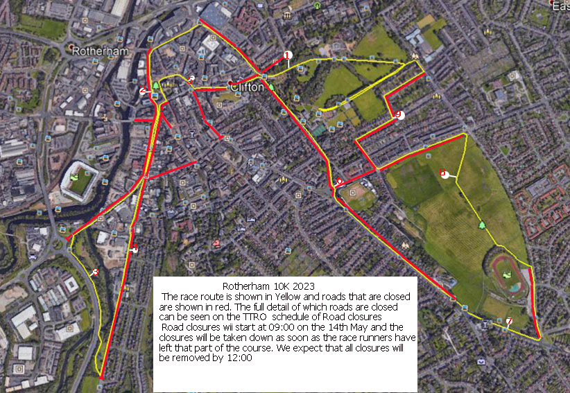
The course starts and finishes in Clifton Park, and is marked in yellow on the map above.
The roads that will be closed for the race are highlighted in red, where there is no red closure marked the runners will be using the footpath. Signage will be in place advising of the road closures ahead and alternative access / egress routes are available for most residential areas during the event.
However, some roads:- Chatham Street, Boswell Street, Badsley Moor Lane (between Boswell St and Clifton Lane), all the streets that are only accessible from Clifton Lane or the closed section of Badsley Moor Lane (Allan St, Albany St, Clifton Mount, Park Mount, Parkfield Road, Clifton Crescent N & S, Old Clifton Lane & Carlton Avenue), will be inaccessible until Clifton Lane is opened (around 11:10).
The western end of Lister Street, Middleton Road & Clifton Grove will be inaccessible between 10:00 and 11:30, but if cars can be parked at the eastern end of Lister Street it is possible to get out into Middle Lane.
Road Closures
| (i) | A6021 Clifton Lane, Clifton from its junction with Doncaster Road to Badsley Moor Lane. |
| (ii) | A6021 Wharncliffe Street, Rotherham Town Centre from its junction with Doncaster Road to its junction with Nottingham Street. |
| (iii) | A6021 Drummond Street, Rotherham Town Centre from its junction with Nottingham Street to its junction with Effingham Square. |
| (iv) | Effingham Square, Rotherham Town Centre from its junction with A6021 Drummond Street to its junction with Water Street. |
| (v) | Frederick Street from its junction with Water Street to its junction with Corporation Street. |
| (vi) | Corporation Street, Rotherham Town Centre from its junction with Frederick Street to its junction with Market Street. |
| (vii) | Market Place, Rotherham Town Centre from its junction with Market Street to its junction with High Street. |
| (viii) | Westgate, Rotherham Town Centre from its junction with High Street to its junction with Sheffield Road. |
| (ix) | Sheffield Road, Rotherham from its junction with Westgate to its junction with A630 Centenary Way. |
| (x) | A630 Centenary Way, Canklow from its junction with A6178 Sheffield Road for a distance of approximately 450 metres in a southerly direction. |
| (xi) | Canklow Road, Canklow from its junction with Castle Avenue to its junction with Coke Lane. |
| (xii) | Moorgate Street, Rotherham Town Centre at its junction with Grove Road. |
| (xiii) | Church Street, Rotherham Town Centre from its junction with Market Street to from its junction with Bridgegate. |
| (xiv) | Upper Millgate, Rotherham Town Centre from its junction with Church Street to its junction with Bridgegate. |
| (xv) | Bridgegate, Rotherham Town Centre from its junction with Upper Millgate to its junction with All Saint’s Square. |
| (xvi) | All Saint’s Square, Rotherham Town Centre from its junction with Bridgegate to its junction with College Street. |
| (xvii) | Effingham Street, Rotherham Town Centre at its junction with All Saint’s Square. |
| (xviii) | College Street, Rotherham Town Centre from its junction with Effingham Street to its junction with Doncaster Gate. |
| (xix) | Doncaster Gate, Rotherham Town Centre from its junction with Wellgate to its junction with Doncaster Road. |
| (xx) | Doncaster Road, Rotherham Town Centre from its junction with Doncaster Gate to its junction with A6021 Clifton Lane. |
| (xxi) | Wellgate, Rotherham Town Centre at its junction with Doncaster Gate. |
| (xxii) | A6021 Broom Road, Broom from its junction with A6021 Clifton Lane to its junction with B6410 Broom Lane. |
| (xxiii) | A6021 Wickersley Road, Broom from its junction with B6410 Broom Lane to its junction with Middle Lane South. |
| (xxiv) | Middle Lane South, Herringthorpe from its junction with A6021 Wickersley Road to its junction with Spenser Road. |
| (xxv) | Badsley Moor Lane, Herringthorpe from its junction with Middle Lane South to its junction with Badsley Street. |
| (xxvi) | Badsley Street, Clifton from its junction with Badsley Moor Lane to its junction with Lister Street. |
| (xxvii) | Lister Street, Clifton from its junction with Badsley Street to its junction with Middleton Road. |
| (xxviii) | Middleton road, Clifton from its junction with Lister Street to its junction with Clifton Grove. |
| (xxix) | Clifton Grove, Clifton from its junction with Middleton Road to its junction with Middle Lane. |